As tropical storms intensify and approach our shores, having access to real-time hurricane tracking is no longer just a luxury—it's a necessity. This powerful tool empowers you to make informed decisions that could save lives.
What You Will Learn
The significance of live hurricane tracking for timely preparedness and safety measures.
How NOAA utilizes advanced technology to monitor hurricanes and provide real-time updates.
Step-by-step guidance on accessing and interpreting NOAA's live hurricane tracker.
Practical tips for beginners to effectively track hurricanes and stay informed.
Essential tools, including NOAA Weather Radio, to receive critical weather updates during storms.
Strategies for integrating live hurricane data into your emergency preparedness plans.
The impact of climate change on hurricane patterns and how to adapt your preparedness strategies accordingly.
How to Track Hurricanes: A Step-by-Step Guide for Beginners
This guide outlines the essential steps and resources for effective hurricane tracking, from choosing tools to integrating data into your emergency plans.
Step 1: Choose Your Tools & Set Up Alerts
• NOAA Live Hurricane Tracker
• National Hurricane Center (NHC) website
• Real-time text alerts from trusted sources
Step 2: Familiarize with Data & NOAA Resources
• Interpret NHC satellite imagery & advisories
• Understand forecast terminology
• Utilize NOAA Weather Radio for critical updates
Step 3: Practice Regularly & Mobile Viewing
• Check updates frequently during season
• Use lightweight mobile apps
• Monitor signal strength and download images
Step 4: Integrate into Emergency Plans
• Update emergency kit based on forecasts
• Communicate with family & neighbors
• Review and adjust plans regularly
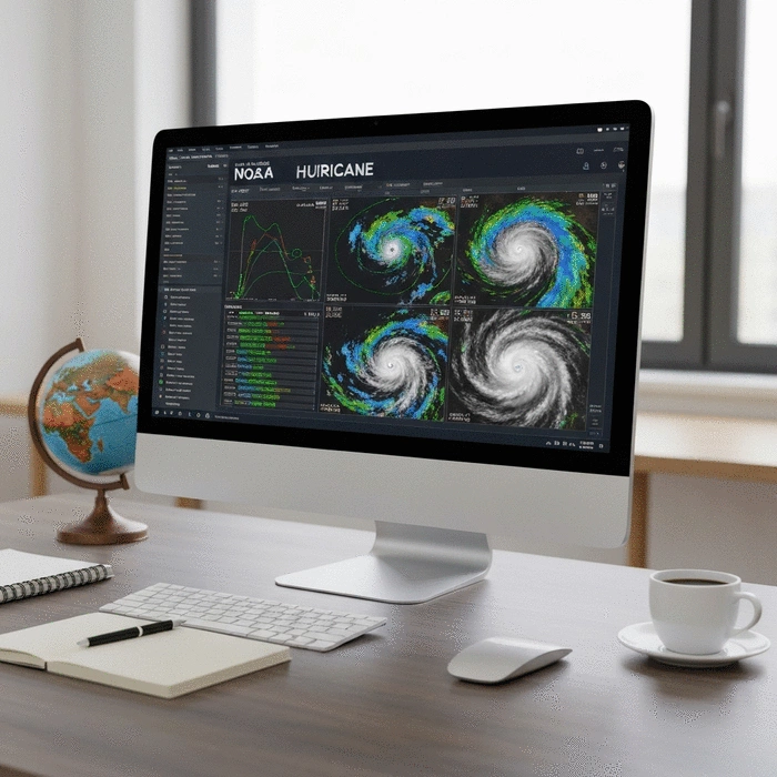
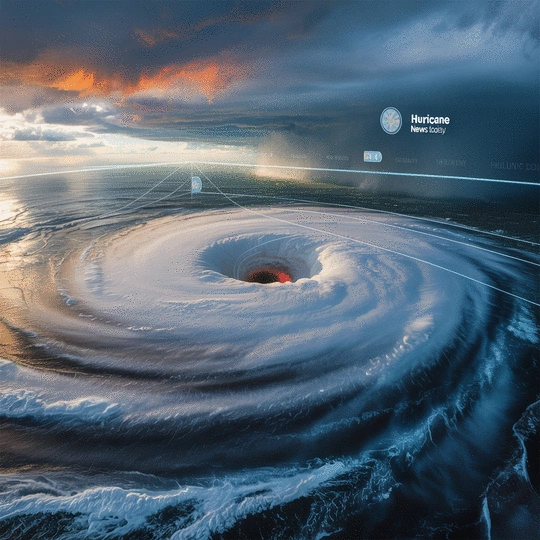
Understanding Live Hurricane Tracking and NOAA Satellite Imagery
Live hurricane tracking is a crucial tool for anyone living in or near hurricane-prone areas. It provides real-time updates on storm developments, allowing individuals and communities to prepare effectively. By staying informed, we can make better decisions about evacuations, securing properties, and ensuring safety during these unpredictable weather events.
The importance of real-time tracking cannot be overstated; it empowers us to act swiftly when storms approach. Hurricane News Today prioritizes providing comprehensive information, so you can feel confident and prepared as storms unfold.
What is Live Hurricane Tracking?
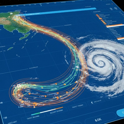
Live hurricane tracking involves monitoring storm systems as they develop, using various technologies to predict their paths and potential impacts. This method combines satellite imagery, weather radar data, and forecasting models to give a clear picture of a hurricane's movements.
Real-time updates on storm intensity and position
Forecasting future paths and potential landfall areas
Identifying safe zones and evacuation routes
Understanding how to access and interpret live tracking information can significantly enhance your preparedness strategy. Trust me, the more informed you are, the more capable you'll be in taking necessary actions during hurricane season!
Overview of NOAA and Its Role in Hurricane Monitoring
The National Oceanic and Atmospheric Administration (NOAA) plays a vital role in monitoring hurricanes through its various arms, including the National Hurricane Center (NHC) and the National Environmental Satellite, Data, and Information Service (NESDIS). These organizations are essential for providing authoritative information and forecasts during hurricane events.
NOAA's comprehensive data helps communities like ours stay alert and prepared. Their satellite imagery and tracking systems are invaluable resources that guide our actions before, during, and after a hurricane.
Accessing Real-Time Hurricane Data: Official Tools and Resources
Locate the Live Hurricane Tracker section on the homepage.
Click on the map to zoom in on specific areas and see detailed storm data.
Use the provided tools to view forecasts and warnings.
This tool is essential for anyone looking to stay informed! By regularly checking these updates, you can ensure that you and your loved ones are prepared for any storm that comes your way.
Exploring NHC Satellite Imagery and Advisories
The National Hurricane Center provides up-to-date satellite imagery and advisories that help us understand current storm conditions. To read and interpret these images effectively, follow these tips:
Look for color-coded areas indicating storm intensity.
Pay attention to the advisories that provide specific warnings and updates.
Use the timeline features to track storm progression over hours and days.
Being able to interpret these images can give you a clearer picture of what to expect, making it easier to plan and respond as needed. Stay connected with these resources, and you'll feel more in control during hurricane season!
The Importance of NOAA Weather Radio for Real-Time Updates
NOAA Weather Radio is a critical resource that provides ongoing updates during hurricane events. It broadcasts real-time weather information and emergency alerts directly to your device. Here’s how to access it:
Make sure it has a battery backup for power outages.
Tune to the local NOAA frequency for your area.
Having this radio on hand ensures you never miss an important update, especially during severe weather conditions. Remember, being informed is key to staying safe!
Engage with Us!
As you think about how to prepare for hurricane season, we want to know: What’s your top tip for staying safe during a storm? Share your insights with us!
Putting It All Together for Effective Hurricane Tracking
Tracking hurricanes can seem daunting, especially for beginners. But with the right tools and a bit of guidance, you can quickly learn how to stay informed and prepared! Let’s walk through some practical steps that will make hurricane tracking accessible and straightforward.
Practical Steps for Beginners to Start Tracking Hurricanes
As someone who has spent over a decade analyzing storm patterns, I understand the importance of reliable information. Here’s a simple guide to get you started:
Set up alerts: Use apps or sign up for text alerts from trusted sources to receive real-time updates.
Familiarize yourself with the data: Understand the terminology used in forecasts and advisories. This will help you interpret the information accurately.
Practice regularly: Check updates during hurricane season to become comfortable with the tracking process.
Remember, the more you engage with these tools, the more adept you will become at understanding hurricane developments. Knowledge is your best defense!
Tips for Viewing Satellite Imagery on Mobile Devices
When you're on the go, accessing satellite imagery can be a challenge—especially if your connection is slow. Here are some best practices to enhance your viewing experience:
Use lightweight apps: Download mobile-friendly weather applications that offer satellite imagery without compromising speed.
Optimize your settings: Adjust the quality settings in your app to balance between clarity and bandwidth usage.
Download images where possible: If you anticipate being offline, consider downloading essential images while connected to Wi-Fi.
Stay updated on signal strength: Monitor your connection to ensure you receive real-time updates when necessary!
These strategies will help you stay connected to vital information, even when your access is limited. Trust me, being prepared is half the battle!
Take Action: Stay Prepared with Real-Time Hurricane Data
Now that you know how to track storms, let’s talk about how to incorporate that information into your emergency preparedness plans. As the owner of Hurricane News Today, I believe that being proactive can save lives!
Integrating Live Imagery into Emergency Preparedness Plans
Real-time data from satellite imagery and trackers can guide your preparedness efforts. Here’s how to link data interpretation with actionable strategies:
Monitor storms closely: Stay updated on the trajectory and strength of hurricanes to make informed decisions about evacuation or sheltering in place.
Update your emergency kit: Use the latest forecasts to ensure your supplies are adequate and ready to go.
Communicate with family and neighbors: Share what you learn with those around you, creating a community of preparedness!
Review and adjust plans: Regularly revisit your emergency plan based on new information and personal experience.
By integrating live data into your plans, you can respond quickly and effectively when a storm approaches. Don’t underestimate the power of preparation!
Frequently Asked Questions About Hurricane Tracking
Q: Why is live hurricane tracking important?
A: Live hurricane tracking provides real-time updates on storm developments, allowing individuals and communities to make informed decisions about preparedness, evacuations, and safety measures, potentially saving lives.
Q: How does NOAA monitor hurricanes?
A: NOAA monitors hurricanes using advanced technologies, including satellite imagery, weather radar data, and forecasting models. Its arms, such as the National Hurricane Center (NHC) and NESDIS, provide comprehensive data and forecasts.
Q: How can I access NOAA's live hurricane tracker?
A: You can access the NOAA live hurricane tracker by visiting the NOAA Hurricane website (e.g., nesdis.noaa.gov/imagery/hurricanes/live-hurricane-tracker), locating the tracker section, and clicking on the map for detailed storm data and forecasts.
Q: What is NOAA Weather Radio, and why is it important?
A: NOAA Weather Radio is a critical resource that broadcasts real-time weather information and emergency alerts directly to your device. It ensures you receive important updates during hurricane events, especially when other communication methods might fail due to power outages.
Q: How can I integrate live hurricane data into my emergency preparedness plan?
A: You can integrate live data by monitoring storms closely to make informed decisions, updating your emergency kit based on the latest forecasts, communicating information with family and neighbors, and regularly reviewing and adjusting your emergency plan based on new information.
Resources for Further Learning and Support
As you build your hurricane preparedness knowledge, consider exploring these resources:
Ready.gov - For emergency preparedness tips and checklists.
Hurricane Watch - To stay informed about storm activity in your area.
These resources will keep you informed and engaged with your community's safety. Feel free to reach out to us at Hurricane News Today if you have any questions—we're here to help!
Understanding the Impact of Climate Change on Hurricane Patterns
Climate change is altering hurricane frequency and intensity, making it crucial for us to adapt our preparedness strategies. Research indicates that warmer ocean temperatures are contributing to more severe storms. Here’s what you can consider:
Stay informed: Follow recent studies and reports on climate change and hurricane trends.
Adapt your plans: Adjust your emergency strategies based on the latest forecasts and data.
Get involved: Join local initiatives focused on climate awareness and community resilience.
By understanding these trends, we can better prepare ourselves for the future. At Hurricane News Today, we’re committed to empowering you with the knowledge needed to face whatever comes our way!
Recap of Key Points
Here is a quick recap of the important points discussed in the article:
Live hurricane tracking provides real-time updates for effective storm preparation.
Utilize the NOAA Live Hurricane Tracker for detailed storm data and forecasts.
Familiarize yourself with NOAA satellite imagery to interpret storm conditions accurately.
Stay connected with NOAA Weather Radio for ongoing updates during hurricanes.
Incorporate real-time data into your emergency preparedness plans for effective action.
Adapt your strategies based on the latest climate change trends impacting hurricanes.
Your go-to resource for live updates, breaking news, and comprehensive analysis of hurricanes worldwide. We help communities stay informed and prepared with our real-time alerts and in-depth safety resources.
Trusted by individuals and emergency responders, our mission is to provide timely and accurate hurricane information backed by seasoned meteorologists and cutting-edge storm tracking technology.
